Site Navigation
Troy Ancient City Map: A Detailed Guide to Exploring the Ruins
Navigate the archaeological site of Troy with our comprehensive map guide. Discover key locations, understand the layers, and plan your exploration route.
Troy Archaeological Site
Hisarlik, Canakkale Province, Turkey
39.9575° N, 26.2388° E
Understanding the Layout of Troy
Key Archaeological Zones
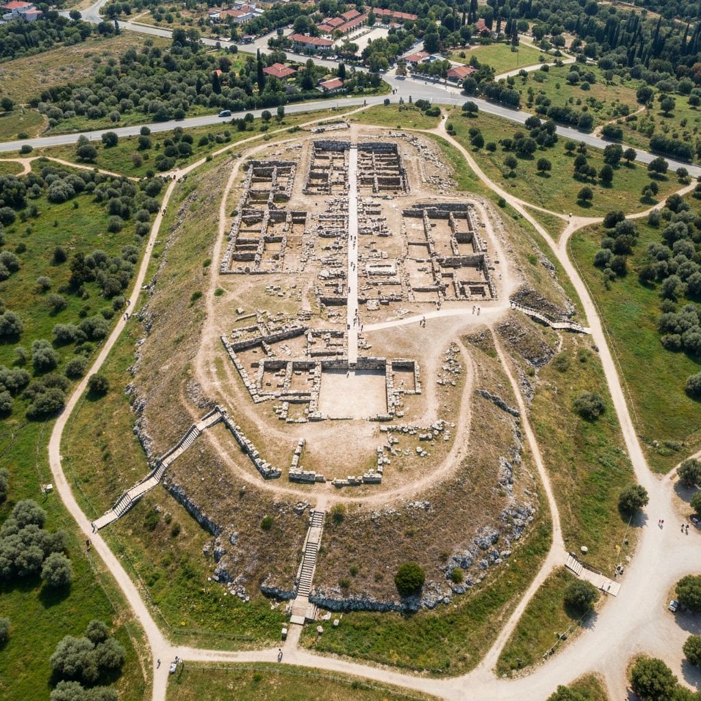
The archaeological site of Troy covers approximately 270,000 square meters. The central mound (tell) contains the remains of the various cities built over millennia, while the surrounding lower town extended the settlement during prosperous periods.
The site is organized around the central citadel mound, with the visitor path winding through different archaeological layers. Informational panels throughout the site help visitors understand what they are seeing.
Site Dimensions
What to See on the Map
Trojan Horse Replica
The iconic wooden horse sculpture at the entrance, symbolizing the legendary stratagem
East Gate & Ramp
The impressive fortified entrance to Troy VI with its monumental stone ramp
Pillar House
A large megaron-style building from the Late Bronze Age citadel
Sanctuary Area
Religious complex including temples dedicated to Athena
Odeon (Small Theater)
Roman-era covered theater used for musical performances and council meetings
Bouleuterion
The council house where civic matters were discussed during the Roman period
South Gate
One of the main entrances to the fortified citadel
Schliemann's Trench
The controversial deep excavation cut by Heinrich Schliemann in the 1870s
Historical Layers of Troy
One of the most fascinating aspects of Troy is its stratigraphy - the visible layers of different civilizations built one atop another. Understanding these layers helps visitors appreciate the immense depth of history at this site.
| Layer | Period | Description |
|---|---|---|
| Troy I | 3000-2550 BCE | Early Bronze Age settlement with simple fortifications |
| Troy II | 2550-2300 BCE | Wealthy city where Schliemann found 'Priam's Treasure' |
| Troy III-V | 2300-1700 BCE | Smaller settlements showing cultural continuity |
| Troy VI | 1700-1250 BCE | Powerful citadel with impressive walls - possible Homeric Troy |
| Troy VIIa | 1250-1180 BCE | Rebuilt city destroyed by fire - most likely Trojan War period |
| Troy VIIb | 1180-950 BCE | Post-destruction settlement with new cultural influences |
| Troy VIII | 700-85 BCE | Greek settlement period |
| Troy IX | 85 BCE-500 CE | Roman Ilium with temples and public buildings |
| Troy X | Byzantine | Final habitation phase before abandonment |
Note:Troy VI and Troy VIIa are considered the most likely candidates for the city described in Homer's Iliad. Look for the impressive fortification walls of Troy VI during your visit.
Planning Your Route
Self-Guided Tour Path
The site features a well-marked walking path that takes visitors through the main archaeological highlights. Follow the numbered markers and information panels to understand each area.
Start at the Trojan Horse
Photo opportunity and orientation
Enter via the East Gate
Marvel at the Troy VI fortifications
Explore the Citadel
Walk through multiple archaeological layers
Visit the Roman Remains
See the Odeon and sanctuary area
End at Troy Museum
Explore artifacts and exhibitions
Accessibility Information
The site has uneven terrain typical of archaeological sites. Some areas have boardwalks and improved paths, but the terrain can be challenging.
- Wear comfortable, sturdy walking shoes
- Limited wheelchair accessibility
- Bring water, especially in summer
- Little shade available on site
- Troy Museum is fully accessible
Ready to Explore Troy?
Plan your visit with information on tours, tickets, and the best times to go.